
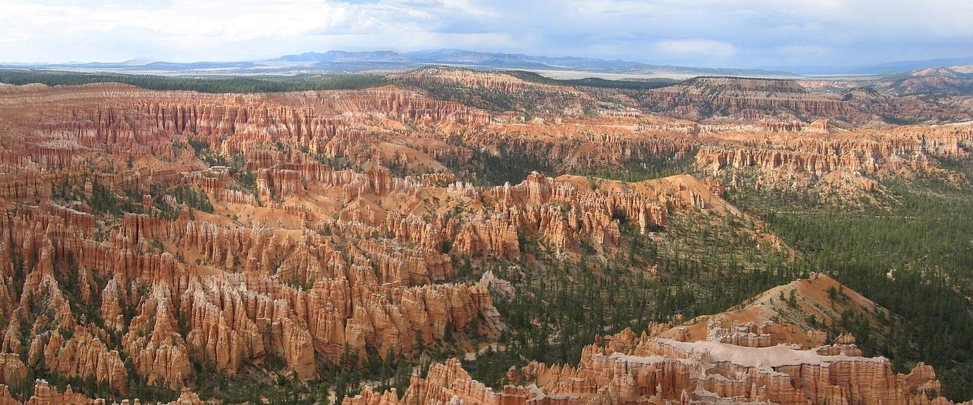
Bryce doesn't get anywhere near the crowds Zion does, and I think that's exactly why so many people rush it — they treat it as a two-hour stop between Zion and the drive east, hit three overlooks, and get back in the car. That's a mistake. The amphitheater is genuinely one of the strangest, most photogenic landscapes in the entire park system, and it rewards you for getting below the rim instead of just looking down into it. Here's my real list, plus the planning details that actually change how good your trip is.
Best Time of Year to Visit, and Why
I'd plan for May through September, but I'll say something I don't say about most parks: Bryce in the snow is genuinely stunning, not just tolerable. Here's my honest reasoning rather than a repeated rule of thumb. Bryce sits around 8,000 feet, a good 4,000 feet higher than Zion, which means it stays noticeably cooler in summer when Zion is baking — a real advantage if you're doing both parks on the same trip. That same elevation means winter is real winter here: snow on red rock is one of the best photo combinations in Utah, and the main park road stays open year-round, so a winter visit is genuinely doable if you're comfortable with cold mornings and icy patches. The tradeoff is that the narrow, shaded sections of trail — Wall Street on the Navajo Loop especially — can hold ice well into late spring, so I'd bring traction devices if you're visiting outside of summer. There's no mandatory shuttle like Zion has, but I'd still use the free seasonal shuttle when it's running; the parking lots at the main overlooks fill up fast on summer weekends and it saves you the hassle.
How Bryce Canyon Compares to Zion
I get asked constantly whether someone should do Bryce Canyon or Zion if they only have time for one, so here's my honest comparison rather than a dodge:
| Bryce Canyon | Zion | |
|---|---|---|
| Terrain | Rim-top amphitheater, you look down into it | Deep canyon, you're down inside it |
| Signature hike | Navajo Loop + Queen's Garden — moderate, accessible to more people | Angels Landing / The Narrows — both genuinely strenuous or technical |
| Elevation | ~8,000 ft — cooler, can snow even in shoulder season | ~4,000 ft — feels warm, can be hot in summer |
| Crowds | Quieter, and easier to escape the crowds on Fairyland Loop | Busier — one of the most visited parks in the country |
| Best for | Photographers, families, and anyone who wants big payoff for less effort | Serious hikers who want a physical, memorable challenge |
If I had to pick just one, I'd pick Bryce for the photography and Zion for the physical challenge — but they're only about 90 minutes apart, and I genuinely think doing both back to back is the better answer if you have the time.
Hiking Checklist — Bryce Canyon National Park
Obviously, for anything beyond a short walk, you'll want real hiking gear, not just sneakers and a water bottle. Here's what I actually bring on every hike in Bryce Canyon:
- A 2–3L hydration reservoir — you drink more when it's easy to sip without stopping, and on shadeless trails that matters more than people expect.
- Blister prevention (moleskin or heel-protector pads) — cheap insurance against the one small thing that can end a big hike early.
- A reliable headlamp with long battery life — for a pre-dawn start or a hike that runs later than planned.
- Real hiking or trail-running shoes with good grip — something rugged for slickrock and exposed sections, something lighter for flatter, easier trails.
- A packable waterproof rain shell — desert storms move in fast, and you want something water actually beads off of, not just "water-resistant."
- A lightweight sun shirt with a hood — many of the best trails here have zero shade for hours at a time.
- High-SPF sunscreen, reapplied — same reason as above.
The 10 Best Things to Do in Bryce Canyon National Park
-
1. Navajo Loop + Queen's Garden
The single best introduction to the hoodoos, and the one hike I'd tell a first-time visitor not to skip. Navajo Loop drops you fast through the narrow Wall Street slot — sheer walls, two ancient Douglas firs growing up out of the shadows — while Queen's Garden is more open, named for a hoodoo that really does look like a profile of Queen Victoria if you squint. I always combine both, descending one and climbing out the other, rather than doing either as a standalone. One thing to know: Wall Street can ice over and stay that way well into late spring, so check current conditions before you commit to that direction. 2.9 mi RT, 600 ft gain, moderate, 2–3 hrs.
-
2. Rim Trail: Sunrise Point to Sunset Point
Paved, flat, and about as easy as trails get in this park, which is exactly the point — it connects two of the best overlooks along the amphitheater edge without asking anything of you. I'd do this one even if you're not planning to hike anything else, or use it as the low-effort bookend to a longer day on Navajo Loop or Fairyland. 1 mi one-way, 100 ft gain, easy, 30–45 min.
-
3. Inspiration Point
My pick for the best sunrise in the park, and most people who've spent a morning here would agree. The amphitheater catches the early light in a way that turns the hoodoos a genuinely different color than they are at midday. Get there early — it's popular for exactly this reason. Viewpoint, easy, about 1 hr.
-
4. Fairyland Loop
The trail I send people to when they've already done Navajo Loop and want more without the crowds. The trailhead alone filters out a lot of foot traffic, and the trail rolls continuously through side drainages rather than sticking to one clean descent-and-climb. About halfway around you hit Tower Bridge, a rock formation that's worth the detour on its own. This is a real commitment, not an afternoon add-on. 8 mi RT, 1,700 ft gain, strenuous, 4–5 hrs.
-
5. Bryce Point
If Inspiration Point is my sunrise pick, Bryce Point is my pick for the single widest view of the entire amphitheater — you can see almost the whole thing from one spot, which makes it a good stop for anyone who wants the payoff without picking a specific trail. It also works well at sunset, and it's one of the standard spots rangers use for evening astronomy programs, so it pulls double duty if you're staying late.
-
6. Drive the Scenic Drive to Rainbow Point and Yovimpa Point
The 18-mile scenic drive climbs more than 1,000 feet from the entrance to Rainbow Point, the highest spot in the park at just over 9,100 feet, with Yovimpa Point right next to it in the same parking area. On a clear day you can see close to 100 miles across the Grand Staircase. If you've got even 30 extra minutes, walk the easy one-mile Bristlecone Loop from the parking lot — it winds through a grove of bristlecone pines, some of which are well over a thousand years old.
-
7. Natural Bridge
A quick, no-hike stop right off the scenic drive — an 85-foot natural arch spanning a gap in the rock, visible from a roadside pullout. It's not technically a "bridge" geologically (it didn't form over water), but the name stuck. Good one to fold into the same drive as Rainbow Point if you're working your way south along the park road.
-
8. Mossy Cave Trail
This one surprises people because it's not in the main amphitheater at all — it's off Highway 12 near the town of Tropic, on the northern edge of the park. Short, gentle, and easy enough for nearly anyone, it follows a small stream to a shaded grotto that grows moss and lichen in summer and ice formations in winter, with a small waterfall along the way. I like it as a low-effort stop if you're driving in from Tropic or just want a break from the bigger hikes. Under 1 mi RT, easy, 25–45 min.
-
9. Horseback or Mule Ride into the Amphitheater
Canyon Trail Rides is the concessioner authorized to run stock into the amphitheater, with 2- and 3-hour guided rides on a dedicated horse trail and part of the Peekaboo Loop, generally running spring through October depending on weather. It's a genuinely different way to see the hoodoos up close without doing the climbing yourself, and it's worth booking ahead since it's popular. I'd treat this as an alternative to hiking, not a replacement for Navajo Loop if you're able-bodied — but for anyone who can't or doesn't want to hike below the rim, it's the best way to still get down there.
-
10. Ranger-Led Astronomy Program
Bryce is a certified Dark Sky Park, and the astronomy program here is one of the more substantial ones in the park system — rangers and volunteers run roughly 100 night-sky programs a year, typically a few nights a week through spring, summer, and fall, plus a multi-day Astronomy Festival in June with telescope viewing and evening talks. Programs are usually held at the visitor center or one of the rim overlooks like Sunset Point, with same-day tickets for evening events available at the visitor center starting at 8 a.m. Check the current schedule before you go, since nights and times shift by season, but if you're staying past dark, this is worth building your evening around.
Build Your Bryce Canyon Trip, Free
I built ParkPlan to turn a list like this into a real day-by-day itinerary with your own dates, travelers, and budget.
Start My Bryce Canyon Trip → Or see my full 1, 2 & 3-day Bryce Canyon itineraryNearby Parks to Pair With Bryce Canyon
Building a longer road trip? These guides sit within a day's drive of this one.
Trail stats, access details, and closures are accurate as of publication but change — always confirm current conditions at nps.gov/brca before you go.