
Glacier is the park that made me rethink how I plan a trip at all. It's enormous, it's split by a single mountain road that's only fully open a few months a year, and half the best hikes are on the opposite side of the park from the other half. I went in thinking I could "do Glacier" in a long weekend. I couldn't — not really. This is the guide I wish I'd had: what's realistic with one day, what I'd add with two, and how I'd actually spend a full four days once I stopped trying to see everything and started picking sides.
If You Only Have 1 Day
One day in Glacier means you stay on one side of the park and you don't apologize for it. I'd base this day around Going-to-the-Sun Road and the alpine world at its top — it's the single best use of a limited amount of time here, and it doesn't require the all-day commitment the Highline Trail does.
Going-to-the-Sun Road — the spine of the whole trip
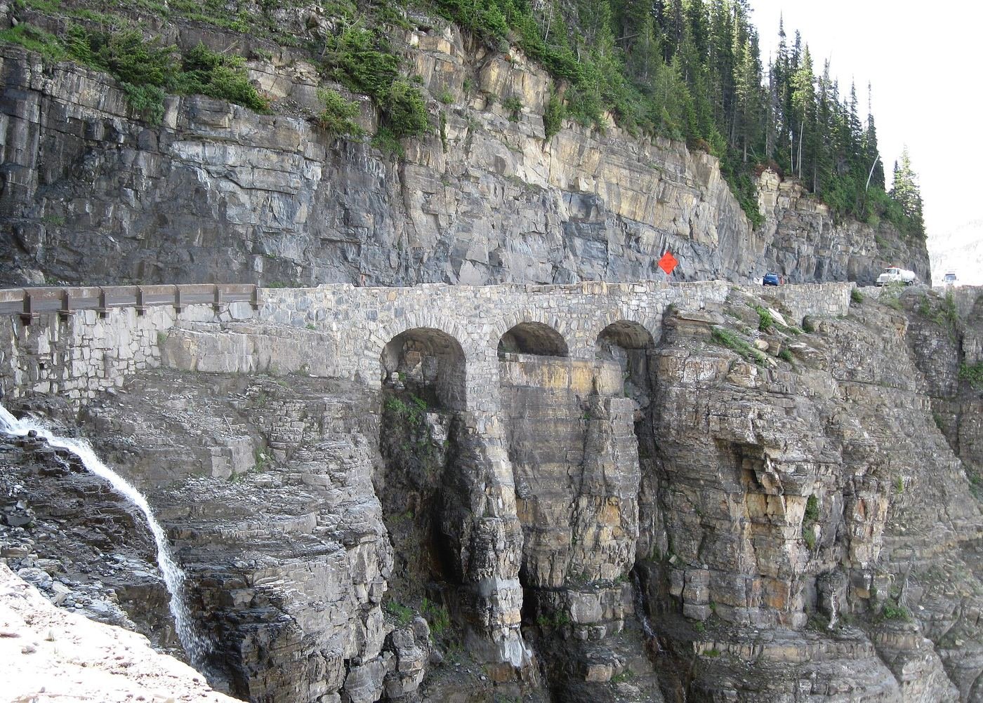
I started early from the west side, at Lake McDonald, and drove the full length up to Logan Pass and down the other side to St. Mary. It's genuinely one of the best drives I've done in any national park — the road climbs from a long glacial lake through cedar forest, then switchbacks up an exposed cliff face called the Garden Wall to the Continental Divide. I pulled off at every overlook I could find a spot at, especially the Weeping Wall and Jackson Glacier Overlook. If I only had one day, I'd rather see the whole road once than rush a single hike.
Hidden Lake Overlook — the payoff at the top
This starts right behind the Logan Pass Visitor Center, which made it an easy add to the drive. The first stretch is a boardwalk over subalpine meadow — I saw mountain goats basically standing on the trail, completely unbothered by hikers — before it climbs a steeper, more exposed stretch to the overlook itself, with Hidden Lake laid out below Bearhat Mountain. It's the best short hike in the park for the amount of effort it asks, in my opinion, and it's the one thing I'd fight to fit into even a rushed one-day visit.
If I had energy left after Logan Pass, I'd stop at Trail of the Cedars on the way back down — an easy boardwalk loop through an old-growth cedar and hemlock grove near Avalanche Creek that feels like a completely different ecosystem than the alpine tundra I'd just been standing in an hour earlier.
Trail of the Cedars — my low-effort last stop
Fully accessible, mostly boardwalk, and shaded the whole way — a good decompression walk after a day of driving and altitude. It's also the start of the trail up to Avalanche Lake if you have more time than I did.
Got a 2nd Day? Here's What I'd Add
With a second day, I gave the Highline Trail the entire day it actually needs. I wouldn't try to combine it with anything else — between the shuttle logistics and the length of the hike itself, this is a one-thing-per-day kind of trail.
Highline Trail to Granite Park Chalet — the big one
I booked a Logan Pass shuttle ticket in advance and started early — this trail gets exposed to sun and wind for almost its entire length, with almost no shade. The first stretch is famous for a good reason: a narrow ledge cut into the cliff face of the Garden Wall with a cable bolted into the rock to hold onto, and a straight drop below the trail on the other side. It eases up after that into rolling alpine meadow with constant views into the valley, ending at Granite Park Chalet, where I caught the shuttle down via the Loop Trail instead of backtracking the whole way. I carried bear spray clipped to my pack strap the entire hike — this is prime grizzly habitat, and I made noise on the blind corners the way the rangers recommend.
If the Highline felt like too much, Avalanche Lake is the honest alternative — a shorter, still-real hike from the same Trail of the Cedars trailhead, climbing a few hundred feet through forest to a lake framed by hanging valleys and waterfalls on the far cliff face.
The Full 4 Days — How I'd Spend Every Hour
Once I had four days, I stopped trying to do everything from one base and split the trip properly: two days on the west side around Lake McDonald and Logan Pass, then two more days on the east side, where Many Glacier and Two Medicine live. The drive between the two sides is long — figure at least an hour and a half from Many Glacier to Two Medicine, more from the west entrance — so I didn't try to bounce back and forth.
Day 3 — Grinnell Glacier Trail, Many Glacier
Many Glacier is, in my opinion, the single best valley in the park for hiking, and this trail is why. It climbs steadily past Grinnell Lake toward Upper Grinnell Lake, with the retreating Grinnell Glacier visible above it the whole final stretch — one of the more accessible ways left to actually see a glacier up close in the park named for them. I'd budget the full day and start at first light; this valley is also some of the densest grizzly habitat in Glacier, so I hiked it with a group and kept bear spray within reach.
Day 3 alternative — Iceberg Lake Trail
If Grinnell Glacier is booked into someone else's plan for the day or you want something slightly shorter, this is the other headline hike out of Many Glacier — it ends at a lake that holds icebergs calved off the surrounding cliffs well into summer some years. I'd pick one or the other, not both, in a single day. If you want something easier that afternoon, Ptarmigan Falls, Redrock Falls, and the Swiftcurrent Nature Trail loop are all shorter options out of the same trailhead area.
Day 4 — Two Medicine, the side most people skip
Two Medicine is on the way to nowhere else in the park, which is exactly why I liked it — noticeably quieter than Many Glacier or Logan Pass even in peak season. I started with the short walk to Running Eagle Falls, sometimes called Trick Falls because part of it flows both above and below ground depending on the season, then took the boat-and-trail combination out to Twin Falls. If I'd had more legs left, Scenic Point climbs out of the trees to a genuinely huge view back over the whole valley — steep, but nothing like the exposure of the Highline.
Where I Ate
I split my meals between West Glacier — a handful of places right at the entrance — and Whitefish, the bigger town about 30 minutes further west with more range.
Eddie's Cafe & Mercantile
In Apgar Village right by Lake McDonald — part grocery, part sit-down cafe. I got the breakfast burrito before an early trailhead start and a slice of huckleberry cobbler on the way back.
View on Google Maps ↗Sunflower Cafe & BBQ
An open-air pavilion at Glacier Campground in West Glacier — brunch and lunch by day, real barbecue several evenings a week. Good option if you don't want a sit-down restaurant after a long hike.
View on Google Maps ↗The Huckleberry Patch
A Hungry Horse institution since 1949 — a cannery, restaurant, and gift shop built around the huckleberry, which is Montana's signature summer flavor. The pie is the reason to stop, not an afterthought.
View on Google Maps ↗Belton Chalet Dining Room
Housed in the original 1910 railway chalet right at the West Glacier entrance. I saved this for my last night — it's the most polished meal you'll find anywhere near the park, and dinner starts at 5pm.
View on Google Maps ↗Loula's Cafe
Downtown Whitefish, open mornings and a few dinner nights a week. Their huckleberry pie has a real local following — I'd get there early on a weekend, it fills up.
View on Google Maps ↗Tupelo Grille
A Whitefish fixture since 1995, and an unexpected find this far into Montana — gumbo, jambalaya, and fresh seafood alongside one of the deeper wine and bourbon lists in the region.
View on Google Maps ↗Where I Stayed
Lake McDonald Lodge & Many Glacier Hotel
Two separate historic lodges on opposite sides of the park — Lake McDonald Lodge on the west side, Many Glacier Hotel on the east. Both book up fast for their short summer season and are worth planning around if you want to wake up inside the park.
View on Google Maps ↗Whitefish or Kalispell, MT
The bigger towns near the west entrance, about 25–35 minutes from West Glacier, with the widest range of hotels, restaurants, and rentals if the in-park lodges are booked or out of budget.
View on Google Maps ↗Fish Creek or St. Mary Campground
In-park campgrounds on the west and east sides respectively — reservable, and the easiest way to be close to the trailheads without the lodge prices.
View on Google Maps ↗Build This Exact Trip, Free
I built ParkPlan because I wanted this kind of plan for every park, not just the one I happened to write up. It turns this into a real day-by-day itinerary with your own dates, travelers, and budget.
Start My Glacier Trip → Or see full park details first at parkplan.org/?park=glacierNearby Parks to Pair With Glacier
Building a longer road trip? These guides sit within a day's drive of this one.
Trail stats, shuttle rules, and road-opening dates are accurate as of publication but change every season — always confirm current conditions, shuttle reservations, and road status at nps.gov/glac before you go.